As an inveterate walker, I appreciate a good map, the hard-copy kind. As a reader, I find a map not only helpful but it often makes a fictional journey seem more real. I love knowing where a character I’m reading about is on a journey, to imagine the scenery and terrain, and to clock the distance. Having hiked the Camino de Santiago de Compostela three times along three different routes, I’m still astounded when I look at a map of Spain just how much land those three journeys covered. I felt every kilometre of it. That’s why I included a map in my novel A Flight of Saints. I wanted to help readers understand the magnitude of the girls’ journey.
Once they escape their convent, Lucia is harangued by her friends for not having even a cursory map. I like to think that once the journey was over, once she was safe, that she sat down and drew one as a way to process all that had happened; to render it in concrete form. I love the map at the front of the novel, charmingly rendered by book designer Stephanie Hofmann, with its subtle markings of pivotal moments.
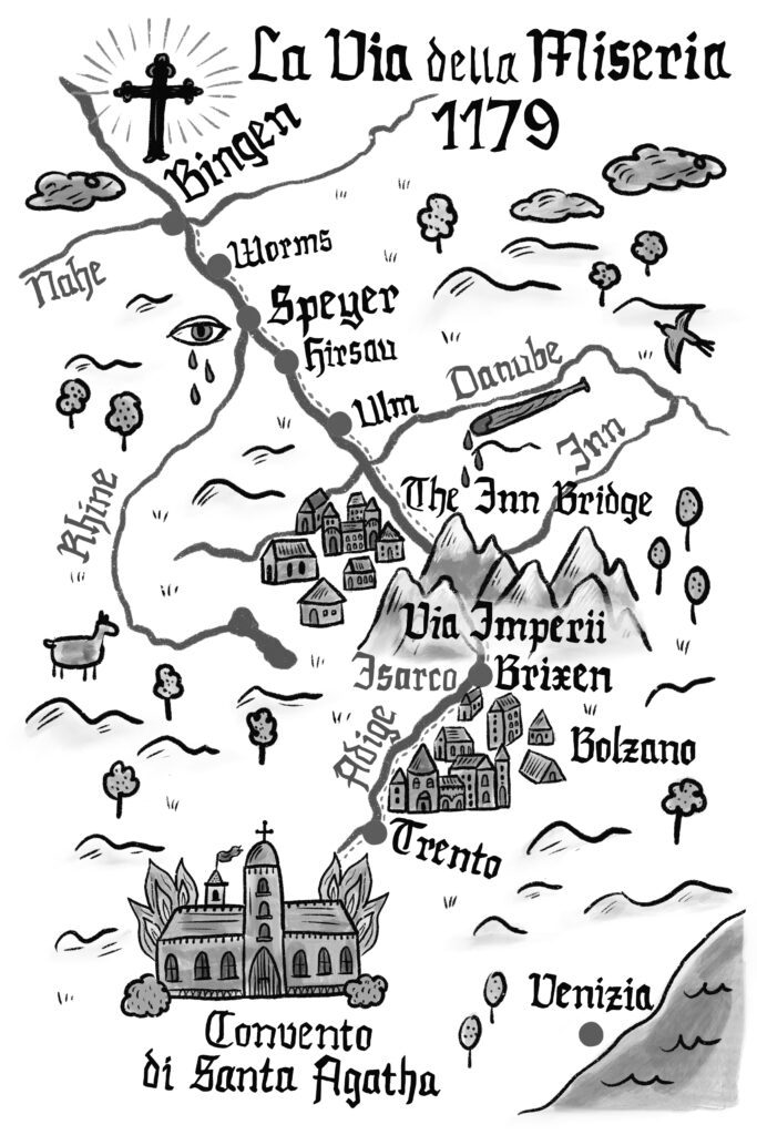
The route my female characters undertook from northern Italy, across the Alps into Germania (present-day Bavaria) was arduous and daunting, but it wasn’t an uncommon one, not even in the 12th century. People and goods had been crossing the Alps for a thousand years or more by then.
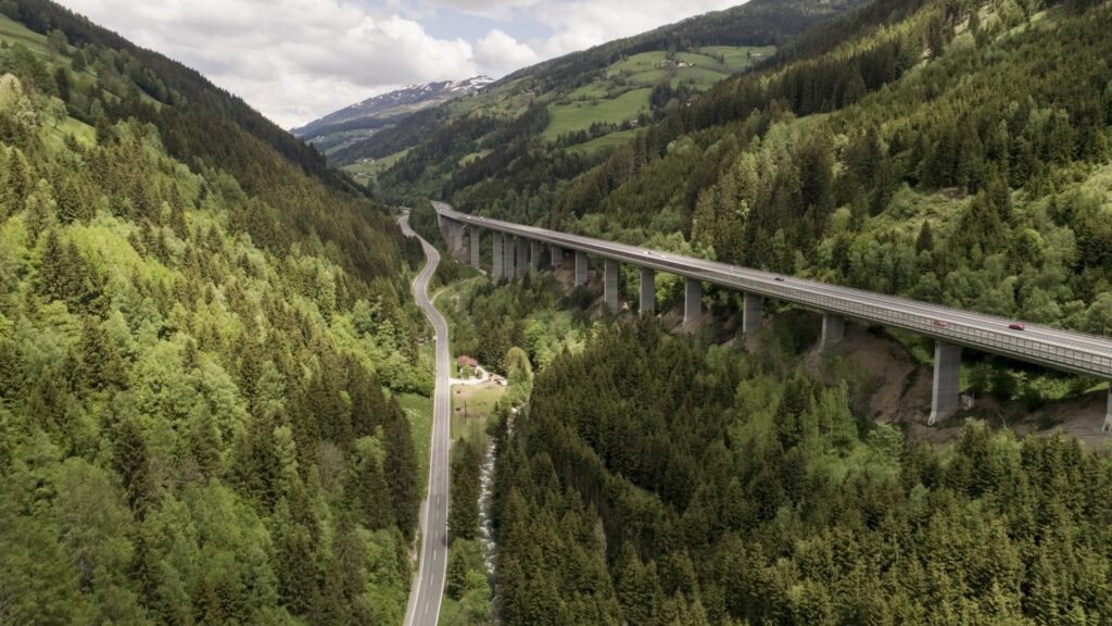
Mountain passes are the logical and natural entry points, and the Brenner Pass is the lowest and most popular of the Alpine ones. During the Etruscan and Phoenician periods, it was the main trading route. Later, the Romans constructed two roads: The Via Imperii from Rome in the south to the Polish city of Stettin (present-day Szczecin) on the Baltic Sea; and the Via Regia from Santiago de Compostela in the west to Moskau (Moscow) in the east. As the Empire disintegrated, so did the most of the roads, but in the case of the Via Imperii, trade continued to flourish between Germany and Italy. Trento, Bolzano, and Inn Bridge (Innsbruck) were important trade stops for merchants; Bolzano itself held four fairs a year where Germans and Italians could meet and exchange goods. Little wonder that, by the Holy Roman Empire, the Via Imperii was the most important road, handling not just merchant traffic but also military, government embassies, pilgrims, as well as palmers and criminals. Unpoliced, it was entirely lawless. Mountains hide all manner of crimes.
The section east of Bolzano through the Isarco Gorge (known today in German as the Eisack Gorge) where the girls meet Clovis the Templar, had deteriorated so much that a detour was constructed that involved a further climb to Lengmoos. Not until the mid 1300s (about 200 years after our girls make their trek) that someone finally tackled the road issues, and the Brenner Pass regained prominence in handling 90% of cross-Alpine business. Today, the Brenner motorway and its stunning Europa Bridge handles both rail and road. It takes about 90 minutes to make the 50-kilometre crossing; in the 12th century, it took the better part of a week.
To map the journey for my characters, I consulted maps and available historic accounts. Satellite maps helped me determine distances as well as possible obstructions and pitfalls. Elevations, rivers, pastures, flora and fauna were all integral to building the scenery of the journey. The terrain would have featured a criss-cross of goat paths, and the remnants of the narrow, cobbled road the Romans constructed. I pictured carts rumbling along while pedestrians kept to the grassy verges. What was in those carts? Salt, timber, wool cloth, furs, spices, metalwork were the most common. What flowers and vegetation grew on that terrain in the month of August when the girls walked through it? What was the weather like? There were no inns, taverns, or amenities: Travellers would have sheltered in the woods for the night. The next inn they saw was likely in the Inn Bridge (Innsbruck). And by the way, the Bär Inn where the girls stayed really did exist then and still operates today.
Naturally, I used my own experience of long-distance hiking on the three Spanish Caminos I’ve done, the most recent being the Via de la Plata from Cadiz to Santiago de Compostela, a distance of about 1,200km. I know what it feels like to have burning feet, throbbing, painful blisters; to be on the brink of exhaustion; to chafe at the presence of squabbling companions and wonder how to ditch them; to know fear when alone and lost; to face yet another steep incline and wonder if there’s anything left in you to get to the top. I also know how quickly negativity vanishes when you stand at the head of a long verdant valley and gaze at the awesomeness of Creation.
The distance from Trento to Bingen is about 730km, almost as long as the first Camino I walked. I covered 20-25km per day, but I had good boots and socks, as well as the funds and convenience to order a café con leche or a bocadillo almost anywhere. No such luxury for my girls. They wore what they had on when they escaped St. Agatha’s, and their footwear was thin leather that wouldn’t have held up to the rigors of the road. I figured the girls were lucky to cover 15km a day, which works out to 48 days to walk 730km. They ran day and night on their first few days of freedom thus covering a fair bit of ground, but then the unexpected popped up: the hedgewitch; the days in the cave with Clovis; rest days in various towns; and the delay in Speyer following Lucia’s horrific experience. That’s about 14 days out of action, which brings their actual walking days down to 34. The cart they rented for the final stretch to Bingen was a help in terms of timing their arrival to coincide with Hildegard’s death.
I’m not sure theirs is a journey I’d want to attempt in real life, though the thought has crossed my mind. I have to be careful though: My husband loves nothing more than a long, challenging walk, and were I to muse about this idea aloud he’d rush to book the trip!